


Côte Bleue Niolon Gd.Méjean

rigol05
User

Length
10.8 km

Max alt
210 m

Uphill gradient
425 m
Km-Effort
16.4 km

Min alt
6 m

Downhill gradient
421 m
Boucle
Yes
Creation date :
2018-04-17 23:27:36.97
Updated on :
2018-04-17 23:27:36.97
3h49
Difficulty : Medium

FREE GPS app for hiking
 SityTrail
IGN / Geographical institutes
SityTrail Plus
The world is yours!
About
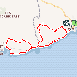
Trail Walking of 10.8 km to be discovered at Provence-Alpes-Côte d'Azur, Bouches-du-Rhône, Le Rove. This trail is proposed by rigol05.
Description
Sortie du 28/03/2018
Correction de l'itinéraire
Le sentier côtier entre la calanque de l'Erevine et celle du Jonquier est par endroit délicat et pas bien marqué.
Positioning
Country:
France
Region :
Provence-Alpes-Côte d'Azur
Department/Province :
Bouches-du-Rhône
Municipality :
Le Rove
Location:
Unknown
Start:(Dec)
Start:(UTM)
682782 ; 4800916 (31T) N.
Comments